GIS Technology Solutions for Malaysia
Explore how satellite-enabled solutions are revolutionizing GIS technology in Malaysia’s most lucrative consultancy domains. Uncover actionable insights and make informed decisions in sectors such as urban planning, environmental management, infrastructure development, and precision agriculture, unlocking new opportunities for growth and sustainability.
Connect with us
Be a part of our green transformation
Satellite-Enabled Solutions: Revolutionising GIS in Malaysia
Using GIS to Improve Disaster Preparedness and Response

Malaysia is a country that is prone to natural disasters, such as floods, earthquakes, and landslides. In recent years, the country has experienced a number of major disasters, which have caused significant damage and loss of life.
In order to improve disaster preparedness and response, Malaysia is increasingly turning to GIS technology. GIS is a powerful tool that can be used to collect, store, and analyze spatial data. This data can be used to identify areas that are at risk of natural disasters, to plan evacuation routes, and to track the progress of a disaster.
GIS technology can also be used to improve disaster management. For example, GIS can be used to track the movement of people and goods during a disaster, to identify areas that need assistance, and to coordinate the efforts of different agencies.
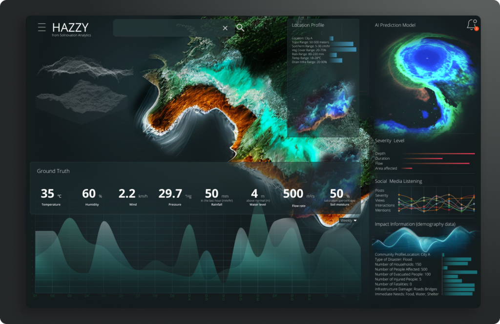
There are a number of GIS technology solutions available in Malaysia. These solutions can be used by government agencies, businesses, and individuals to improve disaster preparedness and response.
Government Agencies
Government agencies use GIS technology to:
Business
Businesses can use GIS technology to:
Individuals
Individuals can use GIS technology to:
Use cases
Here are some examples of how GIS technology is being used in Malaysia to improve disaster preparedness and response:
Government and NGOs using GIS technology in Malaysia
- The Malaysian government is using GIS technology to identify areas that are at risk of flooding. This information is being used to develop flood mitigation plans and to warn people about potential flooding.
- The Malaysian Red Crescent Society is using GIS technology to track the progress of a recent earthquake. This information is being used to identify areas that need assistance and to coordinate the delivery of aid.
- A private company is using GIS technology to help businesses assess the risk of natural disasters to their operations. This information is being used to develop contingency plans and to reduce the impact of disasters.
Consulting
Consulting companies and auditors can use satellite data to improve their work in a number of ways. For example, satellite data can be used to:
- Identify potential risks. Satellite data can be used to identify potential risks, such as environmental hazards, infrastructure damage, and illegal activities. This information can be used to help clients make informed decisions about their operations.
- Assess compliance. Satellite data can be used to assess compliance with regulations, such as environmental regulations and building codes. This information can be used to help clients avoid fines and penalties.
- Improve efficiency. Satellite data can be used to improve efficiency by automating tasks, such as data collection and analysis. This can free up time for consultants and auditors to focus on more strategic work.
Benefits:
There are a number of benefits to using satellite data for consulting and auditing. These benefits include:
- Accuracy. Satellite data is highly accurate and can provide a detailed view of an area. This information can be used to make more informed decisions.
- Reliability. Satellite data is reliable and can be used to track changes over time. This information can be used to identify trends and patterns.
- Cost-effectiveness. Satellite data is cost-effective and can save time and money. This is because satellite data can be collected quickly and easily, without the need for on-site personnel.
ESG use cases for satellite data and audits
Environmental, social, and governance (ESG) audits are becoming increasingly important as investors and regulators demand more transparency from companies. Satellite data can be a valuable tool for ESG auditors, as it can be used to collect data on a variety of ESG-related issues, such as:
- Environmental impacts. Satellite data can be used to track environmental impacts, such as deforestation, pollution, and climate change. This information can be used to assess a company’s environmental performance and to identify areas where improvements can be made.
- Social impacts. Satellite data can be used to track social impacts, such as human rights abuses, labor violations, and community relations. This information can be used to assess a company’s social performance and to identify areas where improvements can be made.
- Governance impacts. Satellite data can be used to track governance impacts, such as corruption, bribery, and financial reporting irregularities. This information can be used to assess a company’s governance performance and to identify areas where improvements can be made.
Satellite-Driven ESG Auditing
A company is being audited for its ESG performance. The auditor uses satellite data to track the company’s environmental impacts. The data shows that the company has been deforesting a large area of land. The auditor uses this information to raise concerns about the company’s environmental performance. The company is then required to take steps to mitigate the environmental impacts of its operations.
This is just one example of how satellite data can be used for ESG audits. As satellite data becomes more affordable and accessible, it is likely that we will see even more innovative ways to use this technology to improve ESG performance.
Benefits:
There are a number of benefits to using satellite data for ESG audits. These benefits include:
- Accuracy. Satellite data is highly accurate and can provide a detailed view of an area. This information can be used to make more informed decisions.
- Reliability. Satellite data is reliable and can be used to track changes over time. This information can be used to identify trends and patterns.
- Cost-effectiveness. Satellite data is cost-effective and can save time and money. This is because satellite data can be collected quickly and easily, without the need for on-site personnel.
FAQ
Here are some frequently asked questions about GIS and satellite data in Malaysia:
What is GIS?
GIS stands for Geographic Information System. It is a computer-based system for collecting, storing, analyzing, and displaying spatial data. GIS can be used to create maps, analyze patterns, and make decisions about the environment.
What is satellite data?
Satellite data is data that is collected by satellites. Satellites can be used to collect data about the Earth’s surface, such as its land cover, vegetation, and water bodies. Satellite data can also be used to collect data about the Earth’s atmosphere, such as its temperature, humidity, and cloud cover.
How is GIS used in Malaysia?
GIS is used in Malaysia in a variety of ways, including:
- Planning and development: GIS can be used to plan and develop new infrastructure, such as roads, schools, and hospitals. GIS can also be used to identify areas that are at risk of flooding or landslides.
- Natural resource management: GIS can be used to manage natural resources, such as forests, water bodies, and agricultural land. GIS can be used to identify areas that are suitable for different types of development, such as agriculture or tourism.
- Environmental monitoring: GIS can be used to monitor the environment, such as air quality, water quality, and land use. GIS can be used to identify areas that are polluted or that are at risk of environmental damage.
- Disaster management: GIS can be used to manage disasters, such as floods, earthquakes, and fires. GIS can be used to identify areas that are at risk of disaster, to track the progress of a disaster, and to coordinate the response to a disaster.
What are the benefits of using GIS in Malaysia?
There are many benefits to using GIS in Malaysia, including:
- Improved decision-making: GIS can help decision-makers to make better decisions by providing them with access to accurate and up-to-date information.
- Increased efficiency: GIS can help to improve the efficiency of government agencies and businesses by streamlining processes and reducing costs.
- Enhanced collaboration: GIS can help to improve collaboration between different government agencies and businesses by providing a common platform for sharing information.
- Increased public awareness: GIS can be used to raise public awareness about important issues, such as environmental protection and disaster preparedness.
Where can I find GIS data in Malaysia?
There are a number of sources where you can find GIS data in Malaysia, including:
- Government agencies: Many government agencies in Malaysia collect and publish GIS data. For example, the Department of Survey and Mapping Malaysia (JUPEM) publishes a variety of GIS data, such as topographic maps, land use maps, and transportation maps.
- Private companies: There are also a number of private companies in Malaysia that collect and sell GIS data. For example, Sky-Shine Corporation (M) Sdn Bhd is a leading provider of satellite data in Malaysia.
- Open data portals: There are a number of open data portals in Malaysia that make GIS data available to the public. For example, the Malaysian Open Data Portal (MOP) makes a variety of GIS data available, such as weather data, traffic data, and census data.
How can I learn more about GIS in Malaysia?
There are a number of ways to learn more about GIS in Malaysia, including:
- Take a GIS course: There are a number of universities and colleges in Malaysia that offer GIS courses.
- Attend a GIS conference: There are a number of GIS conferences held in Malaysia each year.
- Join a GIS user group: There are a number of GIS user groups in Malaysia. These groups provide a forum for GIS users to share information and learn from each other.
- Read GIS books and articles: There are a number of GIS books and articles available in Malaysia. These resources can help you to learn more about GIS and how it can be used.
Connect with us
Be a part of our green transformation